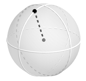
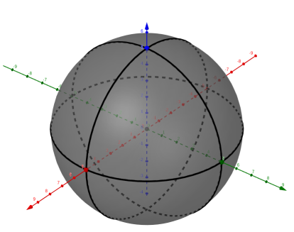
- A sphere is a set of points in space
that are a fixed distance from a given point called the
center of the sphere.
- A radius of a sphere
is a segment whose
endpoints are the center of the sphere and any point on the sphere.
|
|
|
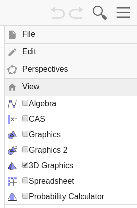
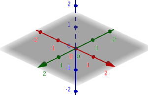
Set-up Geogebra for 3D mode:
|
 |
|
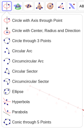
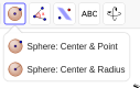
To create a sphere in Geogebra:
NOTE: You can save anything you create in Geogebra to your computer by: Clicking on
and select "ggb" You will now see the "Save file as:" window. You can now change the name of the file ( I suggest calling it "sphere" ) and select the folder you want to save it in ( I suggest you save it in your Google Dirve→Classroom→Geometry folder.
|
   |
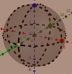
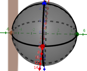
| Task: Use Geogebra to create scale model of the earth, with a point at Newfolden ( 48.356° N )
|
Solution: Step: 1. Put Geogebra in 3D mode, only showing the X, Y, & Z Axis. 2. Create Point A at the origin, intersection of the X, Y, & Z Axis. 3. Create Sphere with center A and radius = 3.959. Average radius of the earth is 3,958.8 miles. 4. Create Intersection Points B & C, with the Sphere and the X-Axis.. - Select Intersection - Click the Sphere - Click the X-Axis 5. Create Point C1, Caption = Newfolden - Select Rotate around Line, 3rd from end - Click Point C - Click the Y-Axis - Rotation angle = 48.356° , counterclockwise - Caption this point as Newfolden 6. Create Ray AC1,"Newfolden" 7. Create Intersection Points D, E, F, & G, with the Sphere and the Y & Z-Axis.. - Select Intersection - Click the Sphere - Click the Y-Axis, for Points D & E - Click the Z-Axis, for Points F & G 8. Create a Circle through 3-Points, for each axis - Click points B, G, & C - Click points B, D, & C - Click points E, G, & D 9. Save this to your computer! You now have a scale model of the earth, with a point at Newfolden ( 48.356° N ) Press Watch the video: |
The are two types of intersections that can occur with a sphere and a plane. A plane will either intersect a sphere at a point or a circle. A plane can intersect ( cut-through ) a plane and the intersection will create a Circle. If the plane intersects the sphere and the center of the sphere we get a Great Circle. If the plane intersects the sphere at a point, the plane will be tangent to the sphere at that point.
|
Intersection: Circle
Intersection: Great Circle
Intersection: Point
|
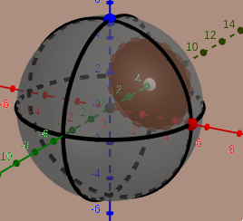 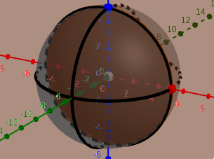    |
Use this Geogebra app to see the interaction when a Plane intersects a Sphere
|
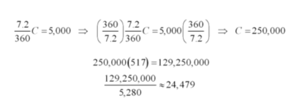
Problem: Calculate the circumference of the Earth with out a calculator! Eratosthenes ( 276 - 194 BC ) calculated the Earth's circumference while living in Alexandria Egypt. At the time he knew that at local noon on the summer solstice in Syene (modern Aswan, Egypt), the Sun was directly overhead. He then measured the Sun's angle of elevation at noon in Alexandria by using a vertical rod, known as a gnomon, and measuring the length of its shadow on the ground. Using the length of the rod, and the length of the shadow, as the legs of a triangle, he calculated the angle of the Sun's rays. This turned out to be about 7.2°. Eratosthenes assumed the Earth to be spherical, and knowing both the distance and direction of Syene from Alexandria, due North about 5,000 stadia ( it is believed that 1 stadia is about 517 ft ). His calculations imply that the circumference of the Earth is about 24,500 mi.
Today, with accurate measurements taken from space, we know that the circumference of a North - South Great Circle is about 24,860 miles and that the circumference at the Equator is about 24,900 miles. The circumference of the Earth estimated by Eratosthenes was with in 2% of the actual circumference of the Earth. If we were to use Geogebra to try and do the same thing, we would need to know the latitude of of bothAlexandria ( 31.200° ) and Seyene ( 24.089° ) 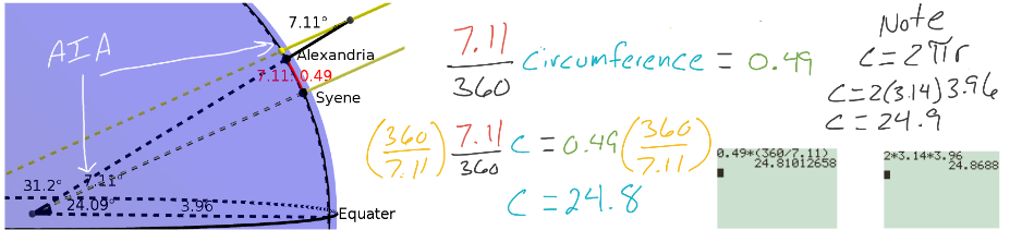 |
Watch the video: Gnomon:  |
|
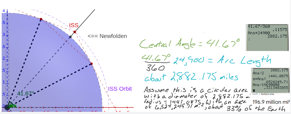
Question: If an astronaut on the International Space Station looks out of a window at the Earth, how much of the Earth do they see? Since there is nothing obstructing a person's sight between the ISS and the Earth, we can use a line of sight coming from the ISS that will be tangent to the Earth. |
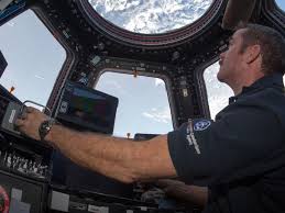 Commander Chris Hadfield, CSA & NASA |
Watch the video: International Space Station ( ISS ) 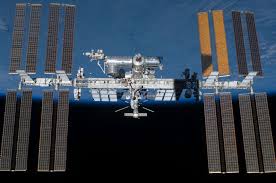 |
|
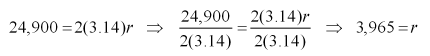
Solution: To begin with, we will need to make an assumption and have some more information. 1st, let us assume that the ISS will be directly overhead of Newfolden. 2nd, we already know that the circumference of the Earth is about 24,900 miles, using this information we can find the radius of the Earth.
Now we know that the radius of the Earth is about 3,965 miles. Next we need to know the distance of the ISS from the earth. This NASA link has all of the information we need: https://eol.jsc.nasa.gov/ESRS/HDEV/. & I.S.S. Tracker Scroll down to the ISS Tracker ( select "Imperial" rather than "Metric" ) and we can see that the ISS is orbiting at an altitude of about 271 miles. Lastly, Newfolden is at a latitude of 48.355° N. Lets model this situation using Geogebra! By the way, remember that the Area of a Circle = (3.14)radius2.
| ||
|
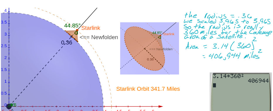
Question: Starlink, https://www.starlink.com/, is a constellation of internet satellites being constructed and launched by SpaceX. Each satellite is about the size of a kitchen table and weighs about 500 lbs. The satellites will be in a Low Earth Orbit ( LEO ) at an altitude of 341.7 miles above the earth. So, how big of an area can a satellite cover for internet service? |
Watch the video: |
|
Solution: Again, we will need some more information and assume that a satellite is directly over Newfolden. However,we can not assume that the satellite can broadcast a signal that will be tangent to the Earth. In fact, the initial angle of coverage will be 44.85° from a radius of the Earth for a total beam angle of 89.7°. Now we have enough information to model this situation using Geogebra!
|
Use the following Geogebra app to help answer the question. Remember you can download the app and use it.
| A. Use the following information to
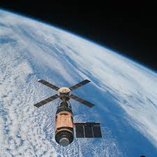
determine how much of the earth could be see from Skylab if they were directly over head of Newfolden.. Skylab was the first United States space station, launched by NASA, occupied for about 24 weeks between May 1973 and February 1974. Major operations included an orbital workshop, a solar observatory, Earth observation, and hundreds of experiments. It spent six years orbiting Earth until its decaying orbit caused it to re-enter the atmosphere. It scattered debris over the Indian Ocean and sparsely settled areas of Western Australia. Orbital height = 275 miles |
 |
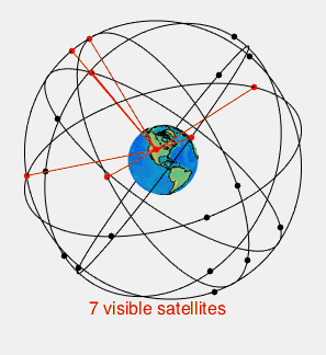
| B. The satellites in the GPS system are
arranged into a constellation, as pictured on the right. Each satellite has an orbit of about 12,550 miles and has total beam angle of about 28°. How big of an area does each satellite cover? |
 |
| 1. Another feature of the Starlink
satellite is that the signal beam can be adjusted. After the Starlink satellite constellation has been fully deployed, the beam angle will be increased to a total of 113.1°. How many square miles will a satellite cover now? |
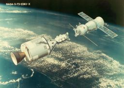 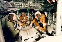 |
| 2.
The Apollo–Soyuz Test Project (ASTP) conducted in July 1975, was the
first joint U.S.–Soviet space
flight. The ASTP involved the docking of an Apollo command and service module and the Soviet Soyuz 19 capsule This mission marked the end of the Space Race that had begun with the launch of Sputnik in 1957. When the two spacecrafts docked, they were orbiting at an altitude of 144 miles. What percent of the Earth could be seen when the astronauts looked out of the window? |
|
| 3. If the United States has an area of
approximately 3.797 million square miles, how many Starlink
satellites will be needed at full deployment to cover the United States. |
|
| 4. STS-1 (Space
Transportation System-1) was the first orbital spaceflight of NASA's
Space Shuttle program. The first orbiter, Columbia, launched on 12 April 1981 and returned on 14 April, 54.5 hours later, having orbited the Earth 36 times at an average orbital altitude of 162 miles. If you were in the shuttle bay and looked up, you would actually be looking down at the Earth. How many square miles of the earth would you be looking at? |
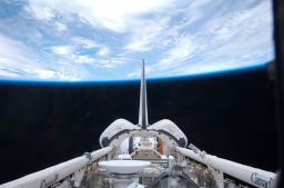 |

 then "save"